
On the 24th of January 2025, Ireland was battered by Storm Éowyn, a weather event that left a significant mark on our landscapes and communities. With ferocious winds, snow and rain, the storm caused widespread damage, particularly through falling trees and downed electrical powerlines. In my local area of Sligo, Sligo County Council immediately began publishing on its Twitter (X) account the location of issues that it had been informed about. In the aftermath of such a disruptive event, it became clear that mapping information about the damage would be useful for effective response and recovery efforts, particularly to communicate visually in map from the location of blocked roads, to help people navigate once it was safe to travel.
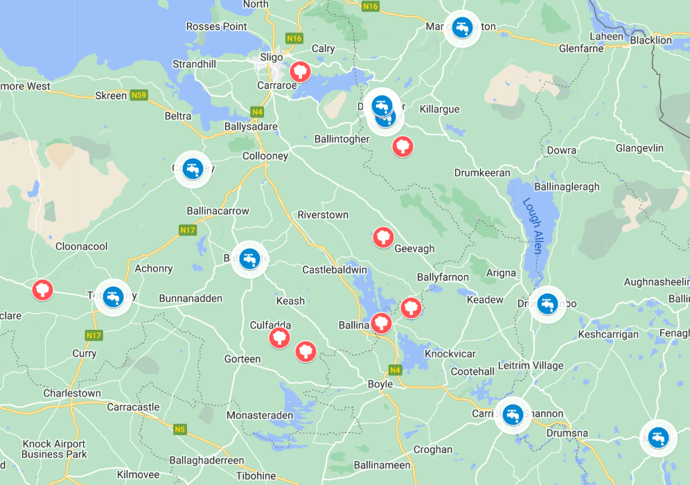
To assist in this endeavor, I created a publicly-shareable Google Map to document the locations of fallen trees and damaged powerlines reported across Sligo which has evolved to include the Recovery Effort and locations offering help and assistance. As of 29th January, we now have 89 locations across Sligo, Leitrim and Cavan offering everything from phone charging, to showers, washing machines, hot drinks and Wifi.
The Role of Mapping in Disaster Response
Maps are invaluable tools in managing the effects of natural disasters. By visualizing the areas most affected by Storm Éowyn, we can:
- Identify Patterns of Damage: Pinpointing clusters of fallen trees and downed powerlines helps highlight the storm’s most severe impact zones.
- Support Emergency Services: Detailed mapping ensures that repair crews can quickly locate and address critical issues, such as power outages or blocked roads.
- Engage the Community: The map allows individuals to contribute by reporting issues in their neighborhoods, fostering a collective response to recovery.
How the Map Works
The Google Map includes:
- Markers for Fallen Trees: These indicate roads or pathways obstructed by debris, helping both pedestrians and drivers navigate safely.
- Locations of Downed Powerlines: Highlighted areas where electrical infrastructure has been compromised, aiding utility companies in prioritizing repairs.
- Community Reports: The map incorporates data submitted by users, ensuring it stays up-to-date and reflective of on-the-ground conditions.
- Map of Roads Blocked in Sligo: Based on crowd-sourced posts from Twitter (X), and Facebook, this section highlights specific routes in Sligo affected by fallen trees and debris, offering localized insights into the storm’s impact.
- Map of Locations offering Help in Sligo/Leitrim: By keeping an eye on Facebook and Twitter (X) posts from local community groups, this section identifies places that are offering free Phone Charging / Wifi / Hot Water / Fresh Water / Showers / Shelter etc.
Collaboration in Action
Creating this map has been a collaborative effort, relying on the input of data published by Sligo County Council, as well as individuals and community groups who have shared information about damage in their areas. This grassroots approach not only enhances the map’s accuracy but also demonstrates the strength of community spirit in times of crisis. A good example of this was the report from Sligo County Council of a tree blocking the road at Caltragh, a townland south of Sligo town centre, which includes residential areas, the main N4 Sligo-Dublin road and country lanes. The location of the fallen tree was marked on the Google Map as ‘location unclear’, but generally located in Caltragh. Within a few minutes, a Twitter (X) user (@SimmyFrog) had responded to me directly and clarified that the fallen tree was at a specific location, just past a Centra store. In other areas, Sligo County Councillor Marie Casserly was able to add additional local information via her Facebook page which had not been published by the County Council on Twitter (X).
Looking Ahead
As we continue to recover from Storm Éowyn, the map will remain an active resource. Anyone can explore it and contribute updates as necessary to build a clearer picture of the storm’s impact and ensure that recovery efforts reach those who need them most.
If you haven’t already, check out the map here and consider sharing any relevant information via this link or via Twitter (X). Every small action adds to the collective recovery effort, and your input could make a big difference in restoring normalcy to our communities.

One thought on “Sligo Community Comes Together Post Storm Éowyn”